Adaminaby Heritage Trail
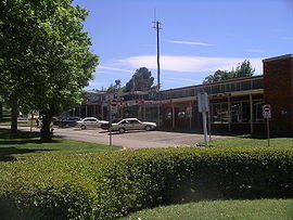
 The Adaminaby Heritage Trail begins at the Big Trout and proceeds through the retail precinct and on a short journey via the historic residential and cultural heartland of the township. Storyboards are located at key sites to interpret and explain the heritage trail.
After visiting seven stations, you return to the Big Trout, and are invited to visit storyboards at the satellite villages of Anglers Reach (central bus stop) and Old Adaminaby (visitor lookout, below Rainbow Pines) and at Old Adaminaby Cemetery.
We recommend that you walk the Adaminaby Town Walk (approx. 40 minutes), and visit the other sites by car (approx 45 minutes for a return visit).
The Town Plan
Adaminaby township is a purpose built village constructed in the early 1960's to accommodate the residents displaced by the construction of Lake Eucumbene. Adaminaby's layout follows closely the principles for the design of NSW towns first proposed by John Sulman in 1897 and widely used up until the late 1960's. Professor Winston of Sydney University was commissioned with the design task and his design features include:
-
 the main highway thoroughfare is removed to the south of the village
 - a green belt separates the highway and the town to buffer the impact of traffic and noise
- a compact rectangular retail precinct with a central 'green-space' plaza
- a main street rising to a higher elevation with premises for commerce, professional services, civic institutions, and churches removed from the retail centre but close to residential areas.
Adaminaby adapted the standard design to incorporate modern features of the 1960's:
- smaller residential block sizes (to acknowledge that space for a cart horse and or milk animal was no longer needed)
- reticulated electricity, water and sewerage to all blocks
- streets are aligned to the contour for aesthetic effect (rather than as straight lines preferred by surveyors and engineers)
- road paving and kerbs and gutters for all residential streets
- planned public planting of trees in all streets.
Construction in the Post-War period and 1960's was constrained by skills and materials shortages, and the modest simple residences and structures of Adaminaby reflect this situation.
Provision of shopping space was to ensure that businesses displaced from the old town were re-established. Restrictions were placed on new business entrants during a 3 year settling-in period, and occupancy has remained much as planned.
Names - Remembering our History
A number of names were considered for the new town, with one suggestion being 'Chifley', to honour the Commonwealth Minister who actively promoted the construction of the Snowy Scheme. In the spirit of 'the move', the name of Adaminaby was adopted.
Street names for were taken from those in use in the old town and draw mainly on the names of founding pioneers or place names, eg Chalker and Denison respectively.
The name of the original settlement is commemorated with the naming of Seymour Park (York St); the former settlement carried this name until the 1880's. The name was dropped in favour of Adaminaby, to avoid confusion with the town of Seymour in northern Victoria.
Please enjoy your journey though our historic past and share your experience with friends and associates. Please stop to ask questions and pass on your comments to our friendly staff in the Adaminaby business precinct.
*Google is changing the way its maps interact with web apps. Trail and touring maps are temporarily unavailable, while we revise our software to meet Google's new requirements.
